Each of the links below provide access to a page (by state) of Appalachian Trail photos. In addition, for the state of Virginia, there are three special groups, each highlighting an area of exceptional scenic beauty and interest. These links are also under "UPWARD CALL's AT PHOTOS" on the Navigation Bar at the top of each page.
Each photo page begins with (large) “thumbnails”. Scroll down through these to quickly see all of the photos in the group. Clicking on a photo will enlarge it. Clicking on the (text) link at the bottom of the photo will take you to the full-size (copy of the) photo further down the page. You can also scroll through the full-size photos.
These groups contain most of my Appalachian Trail photos - I may yet find a few more in scattered slide trays that I haven't yet reviewed. If so, I will add them when time permits.
I hope you enjoy these photos! At the bottom of this page are a few additional notes about my photography!
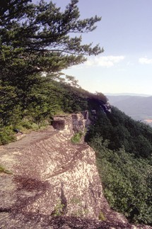
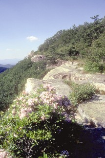
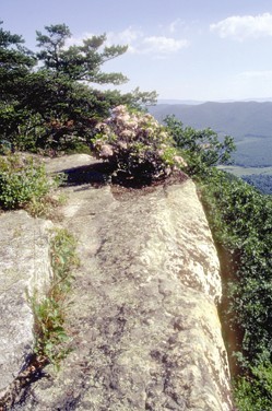
The following three photos, views of Tinker Cliffs between VA 311 and US 220, west of Roanoke, Virginia were the first photos that I placed on the site (and the only ones there for many years). The second one is the photo that appears on my hiking card, which is pictured on the Home page. The hiking card is a standard business sized card - 2" x 3.5". I hand them out to people as I hike and in day-to-day life.
Tinker Cliffs - AT in Virginia
Tinker Cliffs - AT in Virginia with Mountain Laurel in bloom
Tinker Cliffs - AT in Virginia with Mountain Laurel in bloom
Additional note:
During the course of my hiking, I have often not carried a camera. In earlier years, this was due to the (inconvenient) size and weight of my film SLR camera. Even after obtaining my first digital camera, it was still large enough to be a nuisance - requiring frequent repositioning (as it hung from my neck on a strap). Also, there often did not seem to be enough of interest to photograph along many sections of trail to justify dealing with the nuisance of carrying a camera.
I now have a small, but very good digital camera that I can carry in an unobtrusive case that hangs from my belt (or pack strap). For the future, I anticipate having a camera with me nearly all of the time while I hike. Nevertheless, in the course of hiking long day hikes, most pictures, even of especially photogenic scenes are made fairly quickly, making the best of the ground and atmospheric/lighting conditions present during periodic brief stops. Also, in the interest of time, it is often easy to pass by things that would make interesting photographs.
That said, I have made a point of carrying a camera when hiking particularly appealing sections. The Grayson Highlands/Mount Rogers National Recreation Area photos on the site (see above) highlight one of (if not) the most striking natural areas, not only along the Appalachian Trail, but in the entire eastern United States. This is an area that I will continue to visit, long after I complete the Appalachian Trail.
I would be interested in obtaining more photos to enhance this site. If you have any you would like to share, I'd be interested in looking at them for possible inclusion…. Please contact me through my web response form.