My first attempt to hike Longs ended in failure. In my inexperience (and blatant disregard) concerning Colorado weather, we didn't start until about 9 AM.
The 6 miles to the Keyhole were easily traveled. I remember getting there, feeling the western wind, at about 12 or 12:30. We were contemplating the remaining 1.5 miles when we met a returning climber. He told us there was a lot of snow in the Trough, and we should have an ice ax. He also stated it would take us as long from the Keyhole to the top as it had taken us from the TH to the Keyhole!
Reluctantly I turned back, resolving to come back and conquer the mountain at a later time!
I believe this was the hike where it started raining on the return trip. Greg was trailing behind and got caught in a bit of lightning. He still talks of having to duck under some rocks to save his life above treeline!
My second attempt on Longs was similar to the first. I believe we left a bit earlier, but still not early enough. The black clouds were rolling in by the time we reached the Keyhole. It was nearing noon, and clearly we didn't have time to make the summit safely.
I enjoyed climbing the ridge to the left of the boulder field, and staring at the east face of the mountain. We hiked along the ridge a bit, but I don't believe we summited on Mount Lady Washington. The Diamond face was awesome! You'll never catch me climbing down there!
More rain and a long trail ended my second failed visit to Longs Peak.
The weather was nice in September. There was very little mountain snow, if any at all. I badly wanted to conquer a 14er, so off we went to Guanella Pass.
This was a beautiful Sunday afternoon. I went to church, then had lunch and hit the TH about 12:30. It was cool at altitude, but sunny and gorgeous for a late season hike.
We made the summit with no problem. Near the bottom I remember seeing a bull staring at me not far off the trail. Getting gored after hiking a 14er was not my preferred way of ending a nice day. I carefully skirted the bull and got outta there!
I happily returned to town having finally summited a 14er.
The Bierstadt - Evans ridge impressed and worried me. I didn't think I'd ever try that, but maybe!
After making a 14er the previous fall, I was ready to take on some more! This mountain was a beautiful, lovely hike. The weather was fine and the land was gorgeous!
We went up the evening before and camped just west of the TH along CO 82. We got a normal start (for me) of about 8 AM.
The early stages passed thru woods along a creek, through a field (as I recall), and along the creek heading south. The approach thru cuts to the east across a lovely meadow simply covered in wildflowers! The meadow was fairly steep, but not hard and much fun.
The upper reaches had a trail, with occasional snow patches. I remember gazing at Ellingwood ridge and thinking how glad I was to be where I was and not over there! As I now read that the ridge is class 3, I wonder if it really was as tough as I remember . . . I'm going to have to do a bunch of class 3 climbing if I want to hike all 54 Colorado 14ers!
La Plata Peak was (and is) one of my favorites. It was so green and lush early in the season when we went to visit it.
My third attempt to conquer Longs Peak was grounded before it got started. I was determined to get an earlier start and make the summit at last. It was August - snow should not be a factor.
Alas, trails in RMNP were closed, but I didn't know it.
We got to the Longs Peak TH early - maybe 7 or 7:30. It was barred. How disappointing! Whata to do?? I was psyched to hike a 14er on that day, so off we went to the closest option - Grays & Torreys.
The hike, as I recall, was easy and uneventful. We made Grays easily, then the clouds were rolling in over on Torreys. But we left safely.
I had so much energy, since I was prepared for Longs Peak's 15-mile hike, that Don and I did a side hike off an I-70 exit after the 14'ers. It was a full day of driving and walking, but I was glad to have accomplished something worth remembering!
After taking out two at once this same month, I was really on a roll! Hiking 14ers is not so hard!
Since Longs Peak was likely still closed, I found another close 14er. An easy one too! We found quite a few fellow hikers on Quandary Peak. It was only a couple days later that we found out the Denver Post had featured the mountain as its "hike of the week."
The day was rather nice - we had no storm problems. The east ridge of Quandary is a very easy stroll through lovely woods, meadows, and the final summit approach on the rocks. The wildflowers were abundant and colorful. The grass was green, and there were many pieces of dead wood lying around. It looked like driftwood! I took more pictures of flowers than anything else.
This was a truly lovely and easy hike. Perhaps another time I'll try the W ridge, or slide down the S couloir!
PS I may have hiked Quandary before Grays and Torreys, since there were some fall colors developing when we did the latter.
Gotta conquer that mountain! My 4th attempt (3rd actual hike) resulted in success at last. Don had decided to move and was leaving in early August. He consented to hike Longs with me on a Tuesday, two days before heading out.
The weather was not optimal for this victorious assault. We had no thunderstorms, but there was general cloudiness. We had little to look at on this hike - I was unable to see where I would have fallen to, had I been so unfortunate on the Narrows, Ledges, and Home Stretch. But we made it!!
Learning from previous failures, we camped at the TH, and awakened before the sun. We were on the trail at 5:45 AM. Just a tad sleepy . . .
The hike was uneventful through the Keyhole. There was no view of Glacier Gorge, but we had no trouble following the painted rocks over to the Trough.
Even mid-week, there were a fair number of other hikers. We had to be careful of some falling rocks in the Trough. Personally, I found the Trough to be a lot of fun. Being protected, I felt safe, and was able to enjoy the climbing aspects. It went by in no time and suddenly we were at the top of the couloir, just downhill from the summit.
Ah, but so far yet to go! The top of the Trough was exposed, but shrouded in mist. I guess there was a bit of wind, but nothing too serious. The Narrows and Ledges are a bit of a blur. It really was not difficult. The trail was present and solid. There appeared to be quite a drop-off to the right in the fog, but the trail hugged the cliff and provided solid footing. I don't remember any overhangs or other difficult or dangerous spots.
Finally the Home Stretch! The last 500' went fast. Again, it's a blur. However, I do remember being just a bit scared due to the climbing involved on the damp rocks. There really was little danger, but care was necessary. It was good to have Don's calm reassurance in this area, particularly. Before I knew it, I was standing on the summit! It was about 10:20 AM, just 4 1/2 hours from the TH.
We wandered around the summit for awhile. I looked over the E and N faces, at least as close as I dared! There was a slight parting of the clouds in the NE for a bit, and I noticed the plains. Otherwise, there was absolutely no view at all. I regret that, having hiked so far and waited so long for this. But I had made it! Hallelujah!
The trip down was relaxed and easy. Before I knew it, I was plodding down the long trail, past treeline, thru much forest. Then home for a well-deserved crash!
Larry and his friend Bill came for a visit from the East. What better than to take 'em on a 14er?! Grays & Torreys, being close and easy, were the natural choice.
We had a long hike of average speed - what you'd expect with a couple of flatlanders. As the elevation increased, Bill began to get altitude sickness. He felt really bad, and was unable to summit.
By the time Larry finally made Grays, it was getting a bit late, and he was tired! It was a natural to pass on Torreys. But Larry did a 14er!
On the way down Scruffy met the most vicious dog he's ever encountered. A Dalmatian attacked him, picking up his rear end (back) and shaking him violently! Scruffy was suffering badly after we managed to get him free, at long last. He had no broken bones, but was too sore to walk. I had to carry him the couple of miles back to the car. Poor guy!
Grays is a nice hike in a lovely mountain valley. It's worth more visits!
After a hiatus of 9 years, I finally found more hiking buddies to do 14ers. Don moved away when I was 32 and Raoul left that Christmas. My son came when I was 34 and I had house and family to take care of. There were several backpacking trips and occasional outings, but no 14ers.
At work at age 41, I found someone who's into running and hiking! Plus Mike C completed his 14ers over Labor Day. Mike referred me to several others who may want to hike.
Anyway, Ron, his friend John, and neighbor Frank and me went hiking near Salida. We stayed Friday nite at a cabin near Alma. A nice, roomy cabin! We enjoyed some Christian fellowship on Friday evening. Then off to the TH!
We arrived and got on the trail at about 9 AM. Late for some mountains, but Shavano is not too hard. We took the E ridge, from Blanks Cabin TH. It is not the "normal" route, but I don't know why not. The trail was excellent, and relatively easy. Ron and I pushed ahead thru nice forest and across the S slope of the E ridge, overlooking the "Angel of Shavano." It was gone in August - no snow there!
I met a lady on the trail who said she'd hiked them all with no ropes. I believe she used a helmet on Little Bear, though. If that lady could do it, so can I!
The upper part of the mountain involved minimal climbing over rocks. No sweat - we were on the summit by 11:50, I believe.
Mount Tabegauche was 1 mile W, with 400+' drop at the saddle. A few clouds gave us pause, for 2 seconds or so. Over we went! Tabegauche had a fairly small summit area, but no steep cliffs. It was an easy jaunt.
Back on the descent about 1:30, and the Arkansas valley was black with clouds and rain. Areas to the W were dark, but it was fairly light over us. We made it to treeline when it began to hail lightly. I had just stopped to don my rain pants and it quit. By the bottom of the mountain, it was sunny and quite warm.
The sign warned of a 12-hour hike to do Mount Shavano. We notched them both in just 7 hours. John & Frank summited Shavano while we were over at Tab., and then beat us down. We never really hiked with them at all!
After the hike, we "suffered" a mix of modern technology with our outdoors experience. Ron had a computer with wireless phone. Ron and I called home to announce our safe and successful endeavor.
Home by 8 PM, a wonderful trip!
Hiking in August with Ron really fired me up to do some more 14ers! Mom and Dad were visiting from Labor Day for just over a week. I thought perhaps Dad would like to be able to boast about hiking a big mountain. He was up for it!
Mount Sherman is truly one of the easiest 14er hikes in the state. It also is not one of the prettier mountains.
Vehicles can drive to some abandoned mine operations at or just above tree line. A jeep could go even further, but the road was barred at about 11,500' or so. We parked there and started up past the remains of some rather significant buildings. Scruffy and Mokie were along on this one.
The trail was open and broad initially. Dad became short of breath rather quickly, but kept plodding along steadily. I took a prominent branch to the left, which started to peter out after awhile. It wasn't going strongly toward the summit, which we could clearly see to the right. So about a half mile up, we made a traverse over a jumble of rocks over to the main trail. Upon consulting the map later, I discovered either fork would have gotten us to the saddle. Oh well, I believe the R trail was really better for Dad.
Nearing the saddle, there was another cluster of disintegrating relics. We stopped to check things out. Then onward across the open terrain following sparse trails and cairns. We rested at the 13,140' saddle. Mount Sheridan (13,748) is on the left.
As the trail climbed the slope to the N, a cliff began to appear on the W. Dad took numerous rest stops climbing the slope, and the dogs were showing their age. (Well, Scruffy his age, and Mokie his short legs!)
As the trail started to wind ever closer to the drop-off, and even I felt a tad nervous, Dad began entertaining the notion of passing on the final ascent. Just then we met another hiking pair - a 70-year-old dad and his 40-something son. They were from Colorado, but it was the old man's first 14er. This inspired Dad greatly, so we pushed on. After a number of stops we found the broad summit, which required a bit of "flat" hiking to find the tube and marker.
We enjoyed some lunch in the cool wind, and watched some dark clouds over Fairplay. Heading down I met a woman coming up from the Leadville side. She'd done 22 this year. It's inspiring me!
Dad and I had a nice talk on the way down, especially about Mom & her health problems. It's good for him to get it out occasionally. I also had to carry Scruffy a good bit on the descent. He and Mokie were so tuckered out; they laid on the seat without moving all the way home!
As I suspected, Dad proudly boasted of his accomplishment to my brother when he returned home.
This mountain provided a truly memorable and wonderful experience! It was a long, but outstanding day.
Ron had a van he needed to pick up in Colo. Spgs. so that's how Mount Lindsey became the mountain of choice. I met Ron at Union Station, where the bus dropped him off, at 7 AM. On to the Spgs. to pay for the van, then S we went. Mount Lindsey is at the southern end of the Sangre de Cristo range - just east of Mount Blanca.
The Huerfano River valley approach was exquisitely beautiful. We had about 22 miles of dirt road, with the last 6 being a bit rough. The glorious part was the aspens. On this Sept. 25, they were in total glory in this valley. And the day was perfect, barely a cloud, with no threat of rain.
The first adventure was parking in the forest. I backed into a cleared spot and promptly was stuck. The L rear and R front were making good contact. The R rear seemed to have decent contact, but the L front only wanted to spin. For 45 minutes we piled rocks under it to no avail. Finally in desperation, I jacked up the L front and R rear and put a number of rocks directly under the wheels. It worked! PTL!
After this hour delay, we finally got to the TH at 12:50. It was very beautiful and lush. An easy, flat hike turned steep when we forked left up the talus slope. On up thru and around lots of boulders, with a rushing stream to the right.
The basin at 12,000' was large with impressive ridges all around. We stayed to the right (W) on the way up, but ended up having to scramble over a lot of boulders to get over toward Mount Lindsey. Coming back, we took a steep trail down from the NW ridge and across the basin, then along the stream back into the trees.
The view of Mount Lindsey from the basin was intimidating. It looked tough! I knew it to be 2+, but a bit of fear rose up anyway.
Up to the saddle and the NW ridge we went. The wind was ferocious from the S and W. Fortunately, there was no cliff to our left! One route follows the crest of the NW ridge to the summit. It was far too windy to even consider that alternative!
As soon as we entered the N face of the Mountain, with the ridge W of us, the wind died. It was very nice from then on. The trail crossed the N face. It was a good, solid trail. To the left was a moderate scree slope - possibly climbable, but I had no desire to slide down there.
The final summit approaches required climbing on loose rock to our right. We pushed lots of it down the mountain. It really was not very scary, even though it was quite steep. Ron and I were good encouragement for each other!
On the ridge (summit), we had a short jaunt to the left (SE) to find the high point and the tube. The wind was mild, but the temperature was a bit nippy. We got there at 4:10 and stayed for 10 minutes. The view was totally awesome! There were 7 visible lakes to the W on the E slopes of Mount Blanca. We could see many miles in all directions because of the clear air and lack of clouds. To the N, Crestones and Sand Dunes. To the W. Mount Blanca, Little Bear, and the San Luis valley. S was more valley and NW mountains - ranches & farms. E brought the slopes and plains. Awesome!
But being 4:20 in Sept., down we had to go! The return was uneventful. Ron and I felt quite light-headed at our accomplishment. Mount Lindsey was the 2nd hardest climb, next to Longs, that I've done, and I handled it well. In following days I began dreaming more and more of hiking all the 14ers. After all, I've done 10, and Lindsey is ranked harder than 2/3 of them!
We got to the car at 7:05. It was about 6:15 overall, and was just getting dark. I endured a long drive out on the dusty road. My contacts were dirty and it was hard to see and concentrate on the road. Dinner in Walsenburg at 8:45, dropped Ron in C. Spgs. about 10:45, home at 12:37. A wonderful, long day!
Due to a very warm and dry fall, I was able to squeeze in one more 14er this season. Fortunately, I was able to find someone to go with!
It was an absolutely gorgeous fall day. There was scarcely a cloud anywhere to be seen. It was in the 40's, probably, when we set out. I was dressed warmly in long johns and several top layers. Part way up the snow-free trail, I had to strip down to jeans & polypro on the top, and was pushing my sleeves up!
The trail was mostly dry on this beautiful October day. Above treeline we crossed a small snow patch, very much like the type you'd find in any high country location in the summer. The only significant snow was on the final summit approach from the NW. A couple of times I sank to my ankles, and care was necessary to avoid slipping on the rocks.
Anthony got cold on the top and didn't stay long. It was breezy and maybe 15 degrees. I took a good look at the panoramic view. Mount Harvard and Mount Columbia to the N were virtually snow-free. Clearly a long hike over there, I could see. Mount Princeton to the S had a fair amount of snow on its N slopes. Other ranges were distantly visible, although the Elks were quite small in the distance.
We did this hike (7.6 miles) in just over 5 hours, from 10 AM till 3:15 PM. Anthony was a nice companion, but somewhat quiet and even moody. I'll probably hike more with him.
My first winter hike! We couldn't have had a better day. The sun was out all day, clouds were scarce, and the wind was minimal. We had maybe 20 mph winds driving part of the ascent, light winds on top, and virtually none on the descent. By contrast, KP(?) encountered strong winds elsewhere in the mountains on the same day.
We all met and left at shortly after 7 AM. Clothing and snowshoe adjustments prevented starting out until about 8:30. We started out in boots, but quickly donned snowshoes when we began sinking intolerably!
Winter is a great time for crossing the Guanella Pass willows. We walked right over most of them! There really wasn't a huge amount of snow. By the upper third of the mountain, it was mostly bare rocks, and we were able to remove the snowshoes.
About 1/3 of the way up, Chris decided to turn around due to cold feet. No, he wasn't afraid! He simply could not warm up those toes, even though it was not a really cold day. It was 20 degrees or so on the approach, 10 degrees on top, and sweltering on the way down. I was really sweating on the descent - it felt so much like an easy walk in the park.
Richard, Keith, and I easily summited. The view was awesome. On the way down, Richard searched hard for the infamous Guanella Pass ptarmigans. He heard them, but was bummed at no sighting.
Back to the car by 3 PM or so. It was a glorious day!
I must be getting used to this high elevation stuff. Either that, or this Mountain is maximally easy. It hardly seems like we did very much today!
Awake before 4 AM; Mike drove up at 4:45. Off to Leadville. We stopped at Dillon, but McD wasn't yet open since the clock had not yet struck 6! Breakfast at the Corner Stop in Leadville. Yum!
The morning was absolutely gorgeous. The sky was bluer than blue. The snow was whiter than white (from a distance, anyway). The aspens at 10,000' were bright springy green. But the grass & trees higher were . . . brown. (Mostly browner than brown.)
It was very nice to get an early start. Sleep was too short, but I felt great. I believe I got some awesome pictures at this early hour.
We decided on the Twin Lakes approach, which followed Mount Elbert's east ridge. Near the TH we found a number of prosperous beaver dams and ponds. I have never seen so many dams, huge lodges, and cut down trees. Clearly these animals are healthy here!
We hiked across snow patches as we approached treeline. On the ascent, we were able to walk on the crusty snow. By the afternoon, some patches were softening, causing us to occasionally step in up to our calves. Above treeline, we encountered crusty snow about 60% of the time. It was easy to climb and descend, so our snowshoes never left their place of stowing.
Although the upper section became demanding, we reached the summit quicker than really expected. Clouds had started appearing on the Mount Elbert horizon about 10 AM. Looking south, the Sawatch peaks there appeared to be enjoying snow showers. However, Mount Elbert never suffered nasty weather today. It was pleasant on top, and we took time to look around and call our wives. On the descent, the clouds actually parted, and the sky behind Mount Elbert became bluer than blue once again. What a blessed day!
Mike and I enjoyed coffee, lunch, and dessert at the burrito place in the middle of Leadville. The fellowship was wonderful, and we arrived back home at 5 PM, an hour ahead of schedule for a change!
Mount Elbert was truly an easy hike. There were no dangerous cliffs or slopes or loose rock. The day was beautiful. The fresh green at the TH was inspirational, although the tundra has at least a month yet to green up. All in all, a wonderful day and another 14er stimulant!
Once again, we all stayed at Andy's cabin near Fairplay. In the evening, Ron and I whipped the boys in a game of "mosquito - slapping good" horseshoes. It was funny to watch us wander back and forth between throws to elude those suckers!
I was determined to not stay up late, since I had been sleeping poorly before this hike. We made up a funny story as a group, then off to bed at 9 - 9:30. I slept well! The cabin was warm, but cool air coming in the window made it just perfect!
We got away about 7:30 (earlier), stopped in Buena Vista, then got to Winfield soon after nine. The day was beautiful and sunny. Winfield is along a nice stream in a gorgeous valley.
We set off up the trail through the valley at a good clip. Those boys were hiking their first 14er, but they were fast!
The trail through the Clear Creek valley was so lovely! There were many flowers, lush greenery, and flowing water. At the head of the valley sits Granite Peak, a 12er. Looks fairly steep and impressive. Ron was teasing that I should come back after Huron and climb Virginia Peak, (13'er) on the west side of the creek. Ha!
As we ascended through the trees to the east of the creek, the boys left me behind. If I stopped to take a picture, I couldn't catch up! I was already breathing hard!
The trail switchbacked through a beautiful forest, similar to the open character of Mount Yale. We broke into the clear and caught our first glimpse of the summit. It looked so close; Ron bet me that it wasn't the top. He bet me a pop, and I won!
The trail got steeper as we climbed. The final, rather steep summit approach slowed the boys down. I believe I outdid them at the end.
We had a glorious time at the top. Ron read a psalm. The view was stupendous. The Three Apostles', rugged ridges, were prominent to the south behind a lovely open valley. Many other Sawatch Peaks appeared in their glory. Mount Harvard looked awesome. We also managed to see Missouri Mountain, and Mount Belford and Mount Oxford. Those truly are shy peaks - you cannot see them from US 24 or from the road to Winfield.
Our descent was interesting. It was longer because we hiked side trips to Browns Peak (13523') and an unnamed point to the NE of Browns (13400+). Our descent took us down the slopes above Lulu Gulch. We failed to find the best route, since we had a considerable slide and class 2+ route finding over many boulders. We caused a bit of erosion, I'm afraid.
The last part was long. It was hard to believe the main route was only 8.4 miles RT. Back home through cold rain near Copper Mountain.
It was a glorious day. I love hiking!
Mount Evans on July 24 was a disappointing substitute for Crestone Peak. Ron's friend, Mark, was planning to go to Crestone, but plans were delayed by a week. So I had to settle for plan B. Although up to 5 or 6 people were interested, only Mike C. showed up when the appointed time arrived.
We left my house at 6:45 and drove Mike's car to Guanella Pass. The morning was quite nice, and the lots were full at the pass. We set off on the path east through the willows.
Before long, we felt it necessary to head left across the willowy basin, so we could pass left of the sawtooth. There was no discernible trail. We followed bits and pieces of trail, but still pushed and fought bushes for many paces. Many thanks for our Gore-Tex boots were presented upward while crossing this mushy mess.
Finally, the dry higher ground was attained and we continued due east up a gentle meadow. The fellowship was sweet as was the grass green and the flowers lovely. Such a good time was being had that we did not realize that the slope ahead did not belong to Mount Evans.
So, past the meadow, we climbed a small ridge and I noticed a road in the valley to the south. And a lake. And above that was a summit full of people! Mount Evans was clearly over there, across Mount Spalding (13.8). So we got our extra credit summiting of that in too.
We met a nice young man on Mount Spalding who hiked over to Mount Evans on the west ridge with us. Kevin is possibly Christian, being Presbyterian, and a nice fellow. He hiked over & back with us, and joined in our prayer as well.
The west ridge was rocky, but easy. The exposure on the south side was average, while the north side was a cliff. We stayed away from there. Arriving on a summit full of tourists was a novel and interesting experience. I had not encountered that kind of feeling on other mountains. It's strange to see people getting out of cars when you've just worked 4 good hours getting to the summit! I'm sure I felt a greater sense of accomplishment, however.
Mike, Kevin, and I prayed and hiked back. At the Mount Spalding turnoff, Kevin left to hike back to Summit Lake and the car. Maybe we'll see him again.
Mike and I tried hard to avoid the willows on the descent, but to no avail. After much more pushing bushes, and sloshing, we found the Mount Bierstadt trail again and happily found our way back to the car.
I enjoy hiking with Mike C. He is a man full of humor, wit, fellowship, and love for the Lord. An all-around great guy!
This trip was the best outdoor/hiking experience I have ever had. The location was stunning, the fellowship sweet and blessed, and the challenges exciting and met, the weather awesome. We had fun, hiked mountains, met interesting people, enjoyed sunshine, and saw the awesome glory of God in His handiwork. I really feel like it was a slice of heaven!
The group met at 9 at the church. Nat & Martin drove separately, while the 9 of us filled a 15-passenger van. Off to Durango at 9:20 after prayer and hand shakes. Mike C. and Vince were the only approved drivers, so the rest of us kicked back to enjoy the ride. A lot of conversation and getting to know each other occurred over the 6 1/2 hour ride.
After a pleasant leg-stretching stop at Treasure Falls on Wolf Creek Pass, we arrived in Durango with storm clouds brewing. We found our motel by 5 PM and unloaded our packs. Off to dinner at a local steak house - 9 adventurers in a circle. The winds and rain even then were an ominous sign. It will be sunny in the morning for us, won't it Lord?
A couple hours walk around town was fun. It seemed our favorite stores were outdoor places. Some items were even bought! I'd have thought we had everything we needed already! A huge ice cream cone topped off the evening. Everyone turned in with excitement, anticipation, and mild (!) concern about the thick clouds.
Up at 6 AM, last minute packing and stuffing. I didn't sleep real well - what else is new? We got the van packed by 6:30 and were off to the train station. There was some sunshine but lots of clouds as we donned our packs and stuffed them in the box car. There had been a violent storm earlier, about 1 AM.
The train pulled out at 7:30 full of tourists, and excited hikers. The green fields, homes, and golf courses of the Animas R. Valley were standing in water. I couldn't believe the quantity of water standing in the area! And more was apparently on the way, since the sky was quite overcast. Looking north we could see mist in front of the San Juan ridges. To the east, the sun found an opening in the clouds as we slowly chugged northward. The filtered sun cheered us, despite the many clouds. The air was crisp and cool as well.
Although parts of the Animas Canyon were sunny, there was none at Needleton. After struggling with my heavy, over-weighted pack for 20 minutes, we finally got on the trail. It was so dark it was hard to take good pictures on the trail.
As we hiked in, rain came. We had two short showers, which I resisted by not putting any gear on. Sweat was abundant due to exertion and humidity.
About halfway to Chicago Basin, a harder constant rain began. At one point I huddled with Mike P. and Vince under a tree for awhile. Eventually we continued, passing Ron and his boys huddled under another tree. Unfortunately, that was the last we saw of them. Without proper gear, Ron decided to turn back. They missed the glory of the basin and the peaks. Why Lord? Ron wanted to come here so badly!
Well, Nat and others asked the Lord to stop the rain when it became time to set up camp. PTL (Praise the Lord) He answered! The rain subsided for us at 3, and we got tents up in relative dryness. After a warm-up, we made some supper. What fun to see a group of 9 huddled around our "campfire" - our group of stoves!
There were many such huddles over the next three days, and many interesting topics discussed. It was great fun!
Bedtime was early, since we all wanted to warm up in our bags. Thick clouds brought early darkness, and we had no fire to cheer and dry us either.
Wednesday dawned (?) the way Tuesday ended - cloudy and damp. The mist continued to shroud the high point (pt 13425) at the head of the basin. Although the day was dreary, there was no talk of "staying in camp" for the day. We breakfasted on granola and cereal, after emptying a half inch of nighttime rain out of our eating utensils (bowls).
We set out up the steep trail to Twin Lakes in the mist. Fortunately, no actual rain was falling. Once again I was thanking God and Gore-Tex for my waterproof boots. Constant streams and wet grass made soggy and uncomfortable feet for some of the other guys.
Mike A was undecided about hiking the 14ers. He had not been exercising regularly, and the "Sidewalk in the Sky" was worrying him. As we traversed west of Twin Lakes (SE of Eolus), he lagged farther and farther behind. Eventually we concluded he wasn't going to continue. The remaining 8 cheerfully picked our way through the shifting mists toward the east face of the mountain.
By careful route-finding, we managed to find the easiest route up the ledges toward the saddle where the catwalk began. Although the rock was damp, there were no problems as we ascended.
The saddle and the summit were shrouded in mist. We could not see our goal. However, we could see the vicinity of feet. The catwalk was no big deal. There were plenty of handholds at hand level. I don't understand why anyone would crawl across the ridge! The narrow point was fine too! No one had any problem.
Across the catwalk, the NE ridge of Eolus rose above us. However, we would not see it. We carefully followed cairns along the east face. The class 3 climbing was fun and easy, despite the dampness. Before we knew it, we were on the summit! There was no view, but it still was satisfying.
The descent to the catwalk went without incident as well. Mike C. stopped there to make phone calls, so I called Mom. Unfortunately Dad wasn't home. I thought it was so cool to be calling from 13800' high in the San Juans!
The weather was beginning to clear, and we could now see down the valley toward the Animas River (west). A pretty good drop-off from the catwalk, but not terribly frightening. On to N. Eolus, which was another fun and easy scramble. From there, views were developing in all directions. The jagged spires in the direction of Sunlight foretold the next day's adventures.
A snow patch gave us a fun descent from the saddle, whereupon we missed the proper ledge for the further descent. Consequently, several of us had to work rather hard to safely descend several hundred feet on damp sloping slabs. That was the most difficult part of the hike!
The lower descent went well as the sky continued to clear. Back at camp, the warm sunshine beckoned me toward the stream for a high country bath. Then more circling the "fire" (stoves) and manly chatter.
A beautiful sunset was enjoyed, as the crisp cool air descended. Everything was mostly dry - life was very good!
The storm was gone, the air crisp, the mountains gorgeous! During the night, visions (and worries) of the infamous Sunlight summit block haunted me. Would I be able to touch or sit on the summit?
We shook off the frost, and got going before 8. Mike A. stayed in camp from the start.
How glorious to hike in the crystal clear morning! The bright sun cast deep shadows all around us. Looking east toward Peak 13425 and Windom, toward the sun, provided lovely contrasts and colors. Were we ever psyched!
After the steep 1300' climb to Twin Lakes, we paused to enjoy the grandeur of it all. The sun remained perpetually behind and above Windom Peak as we made our way up the rocky slope. From the saddle, it appeared to be easy class 2 boulder-hopping to the summit.
I lagged behind with Troy and Martin. Earlier, I had talked to Troy about being around Christians on this trip. Good example for him, for sure! Anyway, we arrived at a narrow point. I tried the right (south) side of the mountain. Oops! Kinda steep and cliffy over there! The cairns went left.
We arrived at the top, which had a bit more exposure than I expected. I felt a bit shaky as I gingerly made my way to the high point and took a seat.
The views were expansive and awesome! We could see the Utah deserts to the west, and rugged mountains to the north and more mountains and cliffs and valleys to the east and south. And of course, over there sat Sunlight Spire, at 13995'. Thanks Lord, for making sea level where it is! No way would I have interest in tackling those rocky spires!
On Windom we met Kate & Bill, folks that Mike & Vince had met several times while hiking in the Sangre de Cristo range a couple of years ago. Windom was Kate's 46th at age 46! How interesting to meet up here in Chicago Basin!
Well, Bill was ready to head down. Kate was disappointed because she had failed to make Eolus on Weds. due to the weather. If she missed Sunlight, then she'd get only 1 peak for the trip. So we invited her to go with us.
Down the NW slope we went - class 3. It wasn't bad, but required care and attention. Toward the bottom, we all enjoyed a steep snow slide on our butts for a couple hundred feet. It was fun, but I bruised my tailbone, which stayed sore for some time. I also ripped a small hole in my waterproof pants either here or on the summit block later.
The red couloir on Sunlight was easy climbing. Near the top there were 3 or 4 tricky spots, including the "keyhole," but exposure was minimal. A fall would not have taken one off the mountain.
After a few more outcroppings, we reached the spacious summit. Ah yes, spacious except for that final block . . . I took a break to eat and drink, since I was feeling a bit shaky. Nat was sitting on the block, Joby was climbing up and down the lower part, and others were going back and forth. Mike C. went over there and said, "Hey, dude. Come on! You need to go here!"
I summoned my courage and went to the right of the "gap". I stepped over to a solid perch, about 4' below the tippy summit top. Touching it was enough. My shaky body resisted climbing up there on this day. But my head was higher than the highest point. Good nuff!
After a relaxing stay, when the only cloud in the vicinity passed overhead, we headed down. The descent was long down the SW slope, but not too hard. Kate, Martin, and I joined the pastors and Troy above the lakes. So beautiful!
Back at Twin Lakes, pastors Mike & Vince enjoyed (?) a cold swim. I simply enjoyed a bit of sunshine, and the awesome views. I took my bath in the warm sunshine back at camp.
It was so relaxing to have ample time to enjoy camp & fellowship after hiking. Since the train only comes at one time, 4:30 PM, we enjoyed lots of camp fellowship. A slice of heaven, to be sure.
The sun disappeared by 6:30. No clouds for sunset color tonight. Off to bed and more visions of Sunlight's summit block, PTL, it's done!
August 13
Another gorgeous and crisp morning. With no 14ers to hike we had a relaxed breakfast. At 8:45, Mike C., Mike P., Vince and I set off for Columbine Pass. I continually turned to get different views off Mount Eolus, and the upper Chicago Basin.
We met a friendly threesome from Texas up there and encouraged them. Back to camp to pack up at 11:15. Hot sun now! With visions of an Animas R. bath in mind, we made it to Needleton in 2 1/2 hours. There were no clouds to be found. Deep blue Colorado Rocky Mountain skies reigned.
The train ride was awesome. Perfect weather! We talked to various people: a young couple who hiked Eolus that day, a couple from England staying at Fairfield; some folks from Boulder who were hiking 14ers. I hope we left some kind of positive witness with them.
The evening approach to Durango was so enjoyable. Warm sunshine, waving residents, green grass (freshly cut), and long shadows. It was easy to have a thankful heart - full of love and joy. Thanks Lord, for this wonderful trip!!
After Arbys & Quiznos for dinner, we hit the road about 9. More fellowship and chatter ensued, along with napping. Back to the church at 3:30. A marvelous trip! Thank you Jesus!
The most exciting climb yet! Crestone Peak marks the 1/3 point of the complete 14'er challenge. Having challenged and conquered several of the tougher peaks now, I am concluding that I enjoy the harder climbs more. A little class 3 and/or 4 climbing makes for a more interesting day than a simple long trudge up a Sawatch mountain.
Mike and I left on Sunday afternoon at about 1:30. We arrived at the Cottonwood Creek TH in just under 4 hours. The San Luis Valley was beautiful in the late afternoon. The sun was shining and the air was warm.
We set off at a rapid pace, pausing only for a few minutes to speak with leaving hikers. One fellow said, "If you get to Cottonwood Lake, you've gone too far." Huh, wonder just what he meant?
We reached a cozy lair by about 7 PM. We had not yet reached the "boilerplate slabs" between 10,600 and 11,100', but presumed the rocky outcroppings on the trail were the beginning of that area. The light was beginning to fade, so camp was made. Bedtime was early - we had no fire. The night was warm - even hot! My bag and tent are great!
The dim morning light brought us out of our tents by 6:30 and up the trail at 7:10. Steep climbing ensued.
Nearly 2 hours later we were finishing the steep approach to Cottonwood Lake. My first goal was to find the lake, then get our bearings and follow the directions.
By the time we got to the lake, no high summits were visible. We hadn't paid sufficient attention to the northern views when we were west of the lake. From the lake, all we saw to the north was a jumbled mess of rocks, cracks, and cliffs. Not very inviting. . .
We saw a huge cairn N of the lake. It was maybe 4' high. A solo tower? But where to go? We did not carefully study the map. That led us to identify Broken Hank Peak, to the east, as Crestone Needle. What a mistake!
At Mike's suggestion, we began climbing a crack N of the lake. It got difficult. We passed a couple tough spots. I got stuck unable to climb a 30' crack (2' wide & smooth), and unwilling to risk free-climbing the edge of the crack. Mike climbed a side crack that was tricky, and got somewhat higher. This isn't the route, is it? Thankfully, Mike decided to come down and look for the route. But where was it?
We hiked back and to a knoll east of the lake. The grassy saddle between BH(?) and the Needle was NE of us - except we thought it was part of the traverse between the Peak and Needle. Ha!
A quick call (not quick) to Mike C. was only partly fruitful. He couldn't remember the lake, so he couldn't accurately guide us. Another call to Pastor Ray did the trick. Back past the lake to the west, on a knoll, was the grassy basin. Looking north we clearly saw the "red couloir."
On route at last! The lower couloir was steep and ill-defined. We climbed the rocks to the east. I was already getting shaky and tired from the earlier challenge, but this was easy. At 13100' we cut left into the couloir. From there to the saddle was a long rubble scramble. No ice, no slick rocks, no real danger, just steep climbing with occasional hand usage.
And what a view down the NW couloir! What rugged buttresses and cliffs! The NW route looked doable, but probably steeper than the S couloir. Well, we had more class 3 climbing to the summit to the west. It wasn't hard, but I was quite tired by this point. Liberal use of handholds secured my safety!
The summit was fairly small. The cliffs to the north were abrupt. I took care! At 14295', and the late hour, caution was advisable! And what a view! The best yet of any 14er! The Crestones are jagged and jumbled, Kit Carson massive, the valleys serene and peaceful, the Sand Dunes interesting, Humboldt a lump. Awesome panoramic vista from this one!
A little food, some gawking, a short rest, a call to my wife, and we were off. It was great to be back in the "safe" couloir. By 3 PM we were off the steep stuff and I was rejoicing.
Only a rain and hailstorm about 4 made our packing up & return less than perfect. But it was a wonderful hike and trip. Leaving the mountains and San Luis Valley at sunset was a memorable and enlightening experience.
I'm looking forward to another (more) trips to the area to get the other mountains here!
The Lord provided another superlative day for 14er hiking. The weather was great, notwithstanding a "bit" of wind, and the trail was great. The mountain was fun and we had a wonderful time, even enjoying remnants of fall color at the lower elevations.
The morning was gray east of the Front Range, but the high country forecast was "partly cloudy". Sure enough! The sky was Colorado blue just a dozen miles up I-70.
We got a "late start" for summertime hiking, but the fall season carries different rules. Sure enough, there were afternoon clouds, but no lightning.
The trail into Missouri Gulch was beautiful, but steep. Once again, Daniel, the young buck, outclassed us on the lower mountain. I do believe I had greater endurance in the high elevation, however. Ron felt flu symptoms to some degree all day. He commented that that may have slowed him as much as a whole hour on the day.
Upper Missouri Gulch is quite lovely. Gentle Mount Belford rests on the east. The carved north slopes of Missouri lie directly ahead. The east slopes (class 4) do not look tough. Roach describes them as belonging in his nightmares due to their rotten rock. The couloirs are class 3. I carefully studied them both on the approach and the descent. They definitely appeared eminently hikable. They probably are comparable to Crestones difficulties.
We turned right in the basin to reach Missouri's NW ridge. I would take issue with Roach's simple "grassy slopes" description. 2/3 of the 1100' are steep dirt with occasional rocks sticking out. The steepness nearly required hands on the ascent. On the descent, I used some occasional side-stepping to keep myself upright.
The NW ridge has some rocky outcroppings, passable on the west. We wanted to stay off the eastern lip anyway because the strong wind threatened our balance! Ron & son got cold, but I was fine. The temp was probably 35 or more. It pays to have decent gear!
We had a nice, but hazy summit view. Harvard & Huron are quite prominent. I believe I identified Castle, Pyramid, and the Bells amidst the haze. The Three Apostles looked awesome and strangely inviting as well!
On the descent, I climbed NW from the saddle to point 13784 and maybe (?) to 13718 (probably not that far). Ron & Daniel were taking an extended break.
On the lower trail I met another hiker, Kevin, who also had just completed his 19th summit. Next one is another milestone!
This was a wonderful day hiking in a gorgeous area. Not tough, but beautiful and intriguing. Maybe after the list is complete, I'll go back and try a Missouri couloir.
*Left my brother 10 min from the saddle.
Within 10 days I hiked this high circuit twice. Both days were stunningly awesome as far as weather. You could not ask for better October conditions in Colorado. The 14th was somewhat windier. The second time around we enjoyed mild temperatures and almost no wind.
For the first hike, I invited my brother because I thought he might enjoy adding a 14er to his "recreational resume." This was a mistake. Although he had been at elevation in the West for nearly 3 weeks already, his legs and lungs were not up to the challenge. The second hike was more fun. Although Star got sick and Bob was a little slow, no one complained. We all had a good time.
Bob was doing his first 14er, and he got three! Bob had stated before that he wanted to do all the 14ers in 2 years, before he turned 40. I knew the real thing would sober him up! Indeed it did! Driving home, Bob still had enthusiasm for hiking 14ers, but realized that getting even 10 a year would be doing well. He surely does not realize the climbing involved on some of them either! But with experience he should be able to do some of the tough ones.
With my brother, I broke off and did Democrat while he went to the saddle and waited. On 10/23, we all went over there. That side trip is the toughest of the loop. It's a steep climb over a lot of rocks. There was snow on parts of the trail (not much elsewhere!), so we had to take care not to slip. All the church folks loved Democrat. The northern routes looked pretty interesting to me. Maybe I'll try another route sometime!
Herb and Tony were quite fast on the hike. They got ahead of Bob & me leaving Democrat. Bob was faster heading to Cameron than my brother was. I stayed with him. Cameron is a gravel parking lot. Very interesting!
We met up with Tim and Star on the way to Lincoln. She had thrown up twice, and was pale. We all sat on Lincoln and enjoyed a nice view and chatting with other nice hikers. Tony commented on wanting to go to get away from the "exposure." Just wait! If he continues doing 14ers, he'll see some "exposure."
On the 14th, my brother would not let me go to Lincoln. It was getting late & he was slow and irritable. On the 23rd, we enjoyed hiking on the side of Cameron over to Bross. Bob was stronger then and the saddle there is so beautiful.
My brother wanted to skip Bross & head down, but I wasn't confident that it was safe to stay west of the summit. On the 23rd, I observed Bross' west slopes in the morning and concluded it was the better way down. Star felt sick still, so I directed Tim & Star to angle south and get in the descent gully, which they did.
My brother and I crossed the huge summit of Bross, and then went south farther to descend the SW gully. On the 23rd, we went straight west to descend the gully N of the SW ridge. The west gully was a bit steeper with less scree (more feet), but when we hit the deep snow in the middle of the gully, it was great! We descended half the mountain on our butts! That was fun! My brother and I had to work more, although we found a good trail for the final 2/3 of the descent.
One comment on the Bross summit. It occurred to me that the Broncos could play up there. No, in fact, Mile High Stadium could fit up there! Or have a nice concert. Certainly a nice place to lounge around on a nice day, as Roach commented.
Tony had an unwelcome surprise when he returned to his car at Kite Lake - a leaky oil pan. Seems the Saab didn't have quite enough clearance! Well, they had it taped up with gum, adhesive tape, etc. and we took off. Near Pine Junction we stopped again to plug the continuous stream. An hour of jury rigging a patch worked to get Tony safely back to the church by 8 PM. What a day!
Another "uneventful" Sawatch peak. I've now summited 8 of the 15 in the range. Gotta get farther away soon!
After a mild, dry winter and spring, this early season hike was very summer-like. Mike drove and was able to get past the radio towers at 10,820' before any snow was encountered. He actually went another 1/2 mile and parked at about 11,200'.
The day was very nice - one layer of long underwear, with shorts and regular shirt sufficed until the summit winds were felt. It was 28 degrees at the top, the same temperature as at 4:45 AM when we left my house, and variably breezy.
The hike was rather ordinary. There were snow patches. In the morning we crossed a large one of maybe 100 yds. I was a bit nervous about slippage, but all was OK. Returning, we avoided crossing the patches by detouring over Tigger peak (13,300'). I did enjoy boot skiing down 500' or so to the road. I beat Mike and Vince to that point by about 10 min!
The best part of the day was fellowshipping and sharing with my good friends & brothers in the Lord.
Marvelous mountain! Stupendous weather! A wonderful, "perfect" hiking experience! PTL (Praise the Lord)!
Mount Massive is one of my favorite mountains so far. For sheet enjoyment, I'd rank the day on Windom & Sunlight higher, and the joy of climbing Crestone too. Massive would probably be next. We had an awesome day.
Ron and I agreed that Mount Massive is a "near-perfect" mountain. It is not too hard, but has some class 3 opportunities. We climbed in the forenoon, enjoyed expansive openness, climbed some more after N. Massive, hit multiple high points, and topped it off with perhaps 2000' vertical of snow sliding to get back to the valley. It's truly a mountain with something for everyone.
Leaving the church at 6:05, we made the TH by 8:30. The last 25 miles were very pot-holed, but quite passable. It was a lovely morning - not a cloud and perfect temperatures.
We headed west and north into the basin west of Mount Massive. Such a lovely place! The rugged slopes west of us had a lot of snow, probably 50% coverage or more. But the west slopes of Massive were mostly clear. We initially missed the turnoff to the SW slopes route, but that was OK. We had decided to go on up the basin to hit N. Massive first.
At the upper basin, we climbed left up to the S ridge of N. Massive. This was covered with some loose rock and sliding dirt. Due to the judicious use of hands required, we were enjoying some class 3 climbing there. Following the ridge north, we encountered more rockiness, with occasional hand usage required. By this time Bill was lagging. Sore feet and windedness slowed him down. I would guess we spent an hour more on this hike because of Bill than what Ron & I alone would have done. But no matter, we were happy to have him.
Ron was forging ahead and got to N. Massive 15 minutes ahead of us. Roach says the west slope approaching N. Massive "is a special, seldom-visited place." Indeed! Gentle, open, spectacular views, melting rivulets watering all. Loved it!
From N. Massive's west summit, I hit the block on the east summit, then we started down. The descent was "lively", true to description. Easy class 3. Wonderful! The entire ridge over to the main summit and to the S. summit alternated between class 2+ scrambling, class 1 trail hiking, and class 2 bouldering. It is a fun, varied, interesting ridge walk. And the views are awesome for a very long distance. The 6 high peaks of the Elks were clearly visible, as well as Holy Cross and Sawatch peaks to the south.
We didn't see other hikers until the main summit, at which time we saw about 4 others. Not a lot of people up there this day!
Ron and I left Bill above the SW saddle and headed over to S. Massive (+200'). Ron wore me out with that fast climb! My body wanted energy, but not really food. We'd been above 14000' for nearly 4 hours by that time.
The SW slopes descent is clearly steep. Fortunately, we found some long snow patches and had a sliding blast! I earned another tear and duct tape patch for my pants. Certainly worth it! The final descent to the valley was steep trail - Beautiful, but steep. I calculated the SW slope from valley to saddle is 2750' (Roach's #) in 1.5 miles. That's 1800'/mi. or more than 30 degrees for the slope. This slope is only slightly less steep than Crestones S face, covering 2000' in 1 mile. The steepest part of the Crestone couloir certainly exceeds this slope.
Ron asked where I'd rate this hike for length (effort) and difficulty compared to my other 14er hikes. Certainly more difficult are: Long's, Crestone, Eolus & probably Sunlight. Lindsey and Windom were fairly equal. Others were easier or "more trivial." This day on Mount Massive was a hiking day to remember.
We enjoyed a nice drive home on a summery evening after dining in Leadville. Next hike, Lord willing, is June 24.
This hike was my first as the church's "14'er Coordinator." We left with 8 people, although double that many had expressed interest initially. I suppose this is normal turnout!
We met at 6 AM, but didn't leave until 6:35. Costly delays . . . Ann drove, taking Janice, Bill, and David. I took Bob, Mary, and another guy in his 30's (Church). After a stop in Silverthorne, we hit the TH at 9'ish, then on the trail at 9:18.
I determined to stay with the slowest, which was Mary. She stopped quite a few times on those initial switchbacks. A bit further up, Chuck and Bob were waiting, so we 4 hiked together into Missouri Gulch. The other group was ahead, and I never got to chat with them again!
At the Mount Belford turnoff, the other group was ahead and we could see them on the slope to the left. Mary had hiked Belford and Oxford last fall (in 12 hours!), so she wanted to go to Missouri Mountain We four went on up into the upper gulch, meeting Martin and his son coming down from Missouri. They joined us to head for Belford from the upper gulch.
At 12:15 we separated - Chuck and Mary to Missouri, and Bob, Martin, Josh, and I to Belford. The west slope was fairly steep, with a little scree, but not as steep as the NW ridge, which is well switchbacked. Near the top I spotted David heading down. He yelled that they were finished, but "not all made it." Janice had not summited.
We hit Belford in driving snow. I was plenty comfortable, but Bob had cold ears. Missouri looked even stormier. For our part, we experienced no fear or threat. Thunder rumbled overhead just once. Mary and Chuck were not so comfortable on Missouri. Approaching the high point, their hair was buzzing and standing on end. Scary! Prayers and ducking were in order! To escape, they gave up the final high point and rushed down a scree slope they found before getting back to the trail's saddle. I'm so thankful they were OK!
Back on Belford, we headed right to Oxford. Martin & Josh had hiked 2 previous mountains, plus Missouri that morning. They were tired but determined! They (and we) dragged over to Oxford, which was very nice. Then back to Belford. The snow and wind subsided, so things were comfortable (except for aching legs). Bob and I enjoyed some marvelous fellowship on the hike down, since Martin & Josh went ahead.
Bob was suffering some ankle pain, but still gamely went on with enthusiasm. I had a sore spot on my L foot above the ankle. It was a long hike!
We rejoined Mary & Chuck & swapped stories, then hiked down as quickly as possible. Truly, that was faster than the ascent, although Mary & Bob dragged in 15 minutes after Chuck and I.
I must make special note of the beauty of the gulch. On this late June day, life was full and abundant. The grass was green, the trees were growing, but best of all, the flowers were marvelous! There must have been dozens of different kinds in bloom. The lower elevations had larger varieties, including masses of columbines. The higher elevations were totally covered with gorgeous small alpine specimen. Even the summits were alive with the profusion of color. Some of my hike pictures were dedicated to the smaller sights on this day. The loveliness compared to the bloom on Quandary Peak and La Plata Peak.
Well, supper in Leadville restored our energies, and we arrived back at the church at 11:30 PM. Long day, but wonderful.
We hiked three mountains in one day, but the entire effort lasted 2 1/2 days. Vince and I met at Mike's house on the 20th at about 12:30. Mike was ready to go with his three dirt bikes "at bay" behind the van. On the trailer they looked like horses feeding in their stalls.
It's always a great joy to hike with Mike P. and Vince (and also Mike C.). Mike is a very committed Christian and a constant inspiration. He brought up some theological questions during the 4-hour drive to southern Colorado. It was a fun and inspiring ride.
We hit the TH on a warm (hot) afternoon at about 5 PM. After a couple short runs on the bike on the road, and all the pre-hiking arrangements, we set off at 5:45 PM. Things were OK for awhile. The road, which has a warning about expert driving required, got progressively rockier and steeper. After several wipeouts, primarily caused because my rookie right hand could not remember which way was "go" vs. "don't go," we had to ditch the bikes because I broke the clutch handle. Poor Mike tried to ride without it, but it was just too demanding. All told, we rode about 4 miles in a bit under 2 hours. A 50-minute hike got us to the W side of Lake Como as the light was departing. A quick setup of the tents, and some soup in a cup ended the 1st day of adventure.
Friday started at 6 AM. Although the night was warm, I slept poorly. Mike said he slept about an hour. I wonder how much I got. Certainly not enough, although I felt OK as we set off at 7:05 AM.
Around the N side of the lake we went, and then to the S to the "rotten couloir." This couloir was a steep class 2. It was not dangerous, but took a bit of work getting up. Loose scree made for tiresome climbing.
On the S side of the W ridge of Little Bear, we made good progress. There were cairns along the slope, but no real trail. Roach described following the ridge, but traverses on the slope were equally good. We hit the saddle at 12,900' where the ridge "steepens dramatically." Truly it's good we didn't have to climb that!
We soon found our way to the class 4 "shooting gallery". It's a narrow cut, or gully in the small SW face of Little Bear. With Mike and Vince leading, we began climbing. There was a small trickle of water in the gully, so my boots got wet. I did notice the added slipperiness, but it did not cause a problem.
Mike & Vince headed right up the gully's center. I saw easier terrain to the left, so I actually got out of the gully as I climbed. Soon I was some distance from them, but good climbing terrain was above me, so on I went. After awhile, I couldn't see them anymore, but I was strong and confident. There were maybe two times when I reached "an impasse" and feared the climb above. I simply backed down a few feet and went around the obstruction. That is when fear gets started, but so far I've been able to stay calm and handle the challenge.
I arrived on the summit coming slightly from the left, while the others arrived from the right. What a joy to hit that summit! What a blast to get up Little Bear! #27 - halfway, a momentous number! I am ready for the challenge of the Elks and the other tough 14ers . . . I think!
Mike had been considering trying the Little Bear - Blanca ridge. We had discussed it in negative tones, but Mike still wanted to look. We did, and I still had no desire to do it. A couple other guys up there turned thumbs-down, as well. So back we went the way we came. The shooting gallery was easily managed going down; I had no problems at all. There was a 100'(?) rope in the steepest part. I grabbed it because it was there, but didn't need it. I felt very confident, and joyful to have "conquered" Little Bear. It's maybe 4th hardest, per Vince's & Wade's list.
Wade was a guy we met who was hiking & checking GPS readings. Quite the talker! Nonstop! He took a shorter descent off the N side of Little Bear's W ridge. It was pretty steep. The rest of us went back to the rotten couloir, which was no fun either.
Back in the valley, we turned our eyes toward Blanca to the east. From this point on, the day turned into a long slog of a hike. Although the basin was quite pretty, I began to concentrate on putting one foot in front of the other. We passed 4 or 5 lakes above Lake Como, then started up the class 2 or 2+ (N) west slopes of Blanca. No danger here, just lots of rock-hopping and many feet of elevation to gain.
By the summit of Blanca, I was beginning to feel wasted. A rest didn't even help much. I needed salt, or fluids, or food . . . Who knows? The jaunt to Ellingwood was sheer effort. We lost about 500', which wasn't too bad. On the summit, I called my wife, but was too tired to take more than a couple pictures. The long hike down was really hard in my exhaustion. I was sure hoping I wouldn't pass out!
Well, I did make it, but had no energy to hike out & go to Kit Carson. I made dinner after a rest, then enjoyed a nice fire with Wade & others.
Saturday dawned clear & beautiful. Lovely setting - I thoroughly enjoyed looking up at it, and the difficult NW face, in the early morning and late evening.
We hiked and rode out (without power), and got to the cars at 10:15 or so. Vince & I enjoyed some fun runs on the dirt road. Truly, I would not go back to Lake Como to hike Blanca, but perhaps I would to help someone on Little Bear. A truly fun mountain! Home at 5 PM. Good trip!
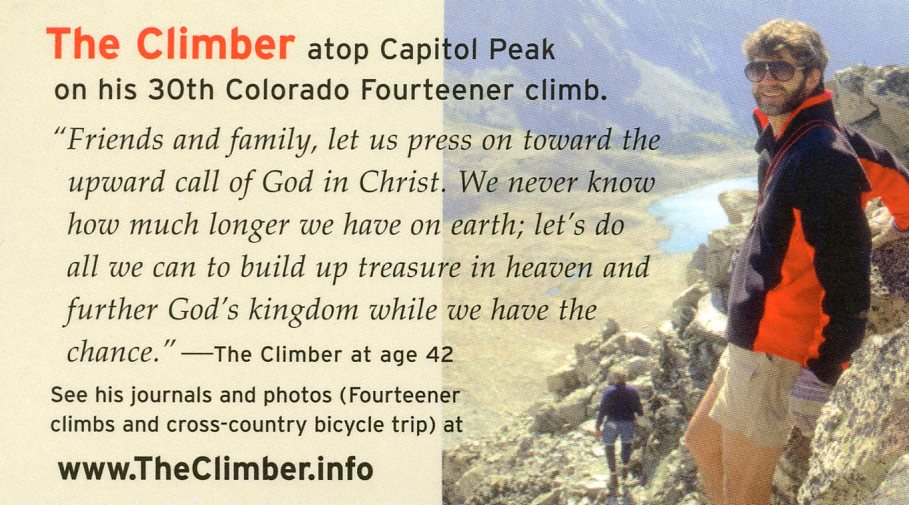
Editor's note: This was The Climber's last entry in his HIKING 14ERS journal. On this, his 30th fourteener, after reaching the summit and safely traversing the "knife edge" twice, he died in a rock slide while crossing the 75 degree northwest slope of sub peak K2 - not more than 30 feet from safety.
What follows is a description of the Capitol Peak trip written by Walt H. He is the person who was closest to The Climber on the mountain at the time of his death.
I am writing to share my experience with The Climber when he fell to his death on the return trip while climbing Capitol Peak, at the request of his brother, "Upward Call".
As of early August of The Climber's 43rd year, I had climbed 47 of the 54 "fourteeners" in Colorado. Three years had gone by since I had done any climbing, and I decided that I should get back and finish off the remaining 7 peaks. I called Vince B., with whom I had climbed several peaks, and asked him to go with me to climb Capitol Peak. Vince told me that a group from his church was going to climb the mountain in mid-August and gave me The Climber's phone number. I had not met The Climber before, but had several phone conversations with him over the next few days. He was always pleasant, helpful and seemed to have a good sense of humor.
I have a place in the mountains, so I drove up there early Wednesday morning. I met the other guys at 9:30 AM and we piled into two cars. The Climber drove one, with Mike P. and Jessie riding with him, while I rode in Mike C.'s car with Herb. We stopped for lunch at Wendy's in Carbondale, which was my first chance to talk much with The Climber in person. I joked with him about how fit he looked compared to me, since I was 13 years older and probably 20 pounds heavier.
We drove on to the trailhead on the west side of the town of Snowmass, arriving at around noon. We got our gear unloaded and ready to go, but The Climber took the initiative to have a time of prayer and take a group picture before leaving. We started off down the trail with Mike C. leading, but soon The Climber took over the lead. I was the oldest hiker and in the worst shape, so I took the pace slower and soon was separated from the rest. Mike P. took mercy on me and dropped back to hike with me. The 6 1/2 mile hike took us a little over 3 hours in mostly rainy weather, and we arrived at the campsite about 5:30 PM.
The other guys were already setting up tents, and they introduced me to Kate and her husband. I found a spot and set up my tent. Soon another hiker, Rick, joined us. We lit camp stoves and warmed up spaghetti & sauce for dinner, along with salad and garlic toast. It started raining hard just before we were ready to eat, so we all stood under some pine trees for shelter, visiting with one another while we ate. The Climber told us he had a special surprise for dinner the next evening after our hike and joked that we would have to catch a marmot for the meat! I turned in early around 7:00 PM in order to warm up and dry off in my tent.
I did not sleep a wink all night, so got up early about 4:30 AM. The others roused around 5:00 AM and we had a breakfast of oatmeal and coffee. Rick got an early start with Kate and her husband, while Mike C. and I left camp about 6:15 AM. The Climber, Jessie and Mike P. did not realize we were going yet, so they started out about 20 minutes after us. We were not worried about them catching us because they were all in better shape. Mike and I climbed the steep incline to get to the ridge and caught up with Kate and Rick. The Climber and Mike P. caught up with us about 7:45 AM as we were approaching the boulder field which led to the ridge where K-2 is located. Jessie had never climbed before and he got a bit freaked out with some exposure (drop-off areas) early on, so he stayed with a younger couple from Indiana who were hiking up more slowly.
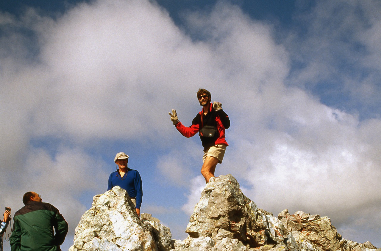
We reached Capitol Peak's east ridge about 8:45 AM where K-2 (technically called Point 13, 662') is the highest point before the actual summit of Capitol. I was the last one to skirt by K-2 and as I did, I felt very uneasy because of the exposure (several hundred feet of drop-off) and the loose rocks so near the edge. I caught up with Mike P. and the others as they crossed the infamous "knife-edge" on the ridge. Then we started up the very steep final 1/2 mile toward the summit, which was made very dangerous by loose rocks. For the last 1/2 mile I climbed right behind The Climber. Several times he turned around to check on me and to ask me how I was doing. He was the last person to summit because I asked him to take my picture as I climbed onto the summit.
We spent about 30 minutes on the summit, enjoying the view, taking pictures and praying together. The Climber had told us on Wednesday that he hoped to get a chance to witness to Kate, since he was not sure of her spiritual standing with the Lord. The Climber chose this opportunity just before prayer to explain to Kate about the group's tradition of reading scripture and praying on each summit. He also asked her where she stood with the Lord and learned that she had grown up a Catholic, but was on a spiritual search.
We left the summit shortly after 11:00 AM and began the tricky descent down. I silently said to myself that I would not feel safe until I got past all the loose rock and exposure on K-2. Descending was harder than ascending because it was so steep and often difficult to find a safe place to plant your feet. We chose our route carefully so we would not end up "cliffed-out" over some drop-off. Finally we made it back across the knife-edge about 11:40 AM. The Climber and I had left our backpacks before the knife-edge to lighten our loads, so we picked them up. The Climber forgot that he had stashed an empty water bottle in the vicinity, so he and I went back to look for it while the others went on up K-2. We found the water bottle, but had gone only a short way before it fell out and bounced down - probably not stopping until it reached Capitol Lake 3,000 feet below!
The Climber and I caught up with Kate, Rick and Mike P., who were debating about whether to retrace their steps and take a higher route. They realized that we were down about 30 or 40 yards lower as compared to the route we had taken on the way to the summit. However, Mike C. and Herb were already 40 or 50 yards above us, having taken that route, so I said it must be okay to go that way since they had made it all right. Meanwhile, Mike P. decided to try a lower route, dropping over a ridge and down into a couloir (ravine), then across to a ridge which led up to the main east ridge below K-2. Mike made it OK, but shouted to us not to try that route, since it was so steep and loose.
The Climber and I started up right together, with Kate and Rick just below us. Twice The Climber kicked a rock loose and turned around to yell "Rock!" at Rick and Kate. The Climber suggested to me that we might be less apt to loosen any rocks if he and I were not quite so close, so I moved over to the right about 15 feet, further away from the steep drop-off. Kate and Rick also moved to the right about 20 feet below me. We were about 40 or 50 yards from the summit of K-2, and Mike C. and Herb were just a few feet from the summit, when it happened. The Climber kicked a rock loose with his foot and turned around to yell "Rock!" The slope was very steep and he had both hands on the ground above him. I was watching from about 12 to 15 feet away, on the same level he was on. Just as he turned back around, his hand loosened a rock which bounced under his stomach and hit again about his feet. Suddenly, without warning, the whole mountainside began to move in a swath about 15 to 20 feet wide, taking The Climber with it. I saw a look of shock and horror on his face as he realized what was happening. Then he was gone, sliding about 20 yards over the steep slope and dropping over the cliff and out of sight. It was a major rock slide with first hundreds, then thousands of rocks falling. While at first most of the rocks were fist-sized, these loosened larger rocks until 200 to 300 pound boulders were falling. The roar sounded like the thunder of Niagara Falls, and in just seconds a cloud of dust was billowing up far above us, hiding everything from view.
The rock slide came within just four or five feet of where I was standing, and I turned to make sure Kate and Rick were okay. Then I yelled up to Mike C. and Herb, "The Climber's gone! The rock slide took him over!" They had seen what happened and immediately dropped to their knees in prayer. I scrambled the remaining yards to the top of K-2 to try to see what had happened, because my view was obscured by the cliff edge and the cloud of dust. At first I could see nothing, but as the dust cleared I saw Mike P. pulling The Climber's body out from under the rocks which had covered his upper body and arms. I watched as Mike tried to administer CPR, but he soon gave up. Herb shouted to Mike, "Don't let him go! Don't let him go! Keep trying!" But Mike answered that it was no use, that he was already gone and that his chest was badly crushed.
All of us were in a state of shock and disbelief. However, Mike C. got on his cell phone within a minute after the rock slide, called 911 and reported the accident to the sheriff. Earlier that morning, the girl from Indiana had chosen to stay on the ridge just below K-2, while her husband and Jessie went on to try the summit. (He and Jessie did summit and made it down okay.) She witnessed the whole accident, because she was on the ridge at the top of the couloir where The Climber fell. She and Kate were crying, while the other men were in shock. I was deeply moved by the accident and found myself crying off and on for the rest of the day, that night and even the next day.
I went on down the ridge from K-2 and saw Mike P. sitting on the ridge above the couloir where The Climber's body lay. I hiked down to Mike, then we both went on down to his body. Mike C. asked us to retrieve The Climber's backpack and car keys, since we would have to drive his car out from the trailhead. We had to lift and move his body in order to take the backpack off. His chest was severely crushed. He had a huge hole above his temple and large gash on the left side of his neck. Both wounds were large enough that I could have put my fist in them. About 20 yards above us were three or four whitish-looking boulders which were almost covered with blood. Mike saw The Climber's camera close to these rocks and retrieved it. Then a rock fell from above and we decided to get out of there quickly before another slide occurred. As we scrambled out, I noticed that The Climber's body was lying about 40 yards from a steep drop-off and surmised that if he had gone over that, his body would have ended up by Capitol Lake far below.
The Climber's backpack was covered with blood, which got on my hands and clothes as I carried it up to the ridge. I climbed back up the ridge toward K-2 and took two pictures of where The Climber fell and one of his body. After conferring with Mike C., he asked Herb and I to go on back to camp, pack up The Climber's tent and things and carry them out. Kate and Rick had already gone on down. The rest of us had hung around for about an hour. Herb and I started down. After about 30 minutes a small plane flew overhead, which had been sent to locate the exact spot where The Climber's body lay, to be able to give mountain search-and-rescue teams accurate directions.
We arrived back in camp about 3:30 PM. A forest ranger met us and asked us to meet a deputy sheriff back at the cars to give a report of what had happened. We packed up things and headed out around 4:30 PM in the rain, carrying our own stuff and The Climber's frame backpack and tent. We met two search-and-rescue members who were going up as we went down, and gave them the details of the accident. Finally we arrived at the cars about 8:30 PM, exhausted, cold and wet after sloshing through ankle-deep puddles and mud.
We loaded stuff into The Climber's car and headed down the 4-wheel drive trail, with no sign of the deputy. We drove into the town of Snowmass, found a pay phone and called the sheriff's office. About a half-hour later the deputy arrived, took our statements, and let us make calls to Denver from his car phone. He told us that he had climbed Capitol Peak twice and knew the exact spot where The Climber fell. He told us that several other people had fallen to their deaths from that same area on K-2. We all agreed that the main reason for the rock slide and The Climber's death was because of the ground being very soft from the hours and hours of rain the previous night and day. Then Herb and I headed for home, assured that The Climber was already rejoicing in his new Heavenly Home!
Walt H.
The plan was that we were all to meet at the west parking lot of the church at 8:00 AM. Some of the men had attended the men's prayer meeting earlier that morning, including The Climber, and when my wife dropped me off that morning at 8:00 only two men in our party were at the parking lot waiting. I recall getting out of my car and jokingly called out, "Where's our fearless leader?" I was referring to The Climber, of course. Pastor Mike C. replied that he had been to early morning prayer and had gone home for a quick shower and would be there shortly.
When The Climber and the others did get there, The Climber suggested that we pray as a group before leaving the parking lot. I rode with The Climber in his car, along with another young climber named Jessie. Jessie rode shotgun, so The Climber spent time getting to know him. Since I was in the back seat, alone, I read. In between segments of conversation up front, The Climber would ask me what I was reading and wanted me to share points on it (I was reading the book, Roaring Lambs). The topic of the book sparked discussion. The Climber had such a desire to witness to the lost. He wanted to know how he could reach out to people at his work and share his faith effectively. He told us how he struggled with timidity in this area, and how some of his previous "sharing" had had negative effects! He also talked of his concern for the salvation of Kate and Bill, two hikers that we all met on a mountain last year and who had hiked with us on various peaks since that meeting. The Climber encouraged us to pray for opportunities to share with them (he had such a heart for others!).
After parking our cars at the trail head, we all hiked seven miles in to base camp and set up camp for the night.
On Thursday, The Climber and I left camp about fifteen minutes later than the rest of the group; we had wanted to take some sunrise shots with our cameras. We then lagged behind the group for a while. We talked a lot as we hiked together. The Climber shared how proud he was of his dad climbing Mount Sherman with him. We talked about how God seems to put opposites together to balance us out; me with my wife, and he with his. He loved being around people and crowds, whereas his wife always did better one-on-one, he said. He also talked about what a great house decorator his wife was and how sometimes he had to put the breaks on her for financial reasons!! :-) He told me how much he loved her and his kids. The Climber had even changed the hiking trip dates so that he could be in town for a Back-to-School Night meeting. This was The Climber. He was very involved with his family. During the hike, he got excited about the beauty and said how he really wanted to bring his family back up there in the fall to see all the aspen trees ["never to climb the peak, though! Only for a short little family walk!", he said :-) ].
Our group made it to the top of Capitol by 10:30 that morning and, as our tradition goes, we prayed. Mike C. and I called our wives from "the top", as we often do, but The Climber opted not to call from there. He wanted to wait to call his wife until after the K-2 area when all of the technical stuff would be behind him so that he could let her know that he was all right and heading down. I am sure that his final thoughts were of concern for his wife and the kids.
We all took our time on the hike. The Climber was always cautious and very safety minded, and we were glad to follow his wise example. He was forever looking out for everyone else. "Are you sure you feel up to this climb? You don't have to do it, you know." "Do you have enough water?"
I had chosen to go on a slightly different route on our descent, and was about 100 feet below the others, having just crossed a boulder field, when I heard rocks breaking loose from above. I looked up and saw the whole thing happen within seconds and was helpless to do anything about it, which is a terrible feeling. I was able to get to him in about two minutes from the time he stopped falling. I hurriedly took boulders from off of his body, checked for vital signs, and began CPR, but could tell, due to other significant signs, that it was not going to revive him. The whole thing was a nightmare, however, I know he is with the Lord. When I found him, The Climber had a peaceful look on his face, as if he were in a deep sleep, not one of terror.
Just so you know, The Climber was not walking too fast, he was not careless with his footing, he was not going over strange terrain, etc. He was on "the trail", he was right where everyone walks, he was "right where he should be." The rock just gave way at the moment The Climber's foot stepped on it. I believe God is sovereign, and it didn't take Him by surprise. God has the whole picture, and we need to look to Him to pick up the broken pieces.
The Climber was a true friend, a brother-in-the-Lord, someone who made a difference in my life. He will be missed, but I am comforted in knowing that I shall see him again and resume the sweet fellowship we had together one day.
Mike P.
"This was a long climb, with considerable exposure beyond the knife edge ridge, and loose rock. Unfortunately, one of the climbers in the party ahead of me was killed on the traverse below K2. He was returning from the knife edge on the standard route when a section broke loose without warning. I am very fortunate that two members of his party stayed behind to point out unstable parts of the traverse, because I did not know a rockslide had occurred. You can debate what class this mountain is in or whatever, but it is definitely one where you can do everything right and still not make it back."
I had to take my long-time companion to the vet yesterday and send him on to a better place...
Scruffy was the best dog one could have ever wanted. He had the right mix of independence, loyalty, and fun. We enjoyed many a hike, run, and walk together. My wife found him just 2 months after we were married - he was always with us.
In Sept. 98, Scruffy hiked Mount Sherman with Dad and me. He did well, even though I had to carry him part of the way down the mountain. That was his last significant hike. We even quit taking him on local walks sometime last year.
Scruffy's sight and hearing were failing badly, and he had gum disease. The past week he had blood in his urine and was getting quite unsteady on his feet. Yesterday (1/18) we could not even get him to take ham and cheese... so it was time. I cried at the vet...
We have Mokie, who still had not adopted me like Scruffy did. I do hope to have a dog like Scruffy again someday.